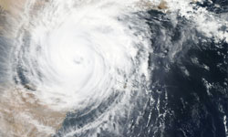
Hurricane Polo is a reminder that a storm's most dangerous moment isn't always its strongest one. It was a Category 5 over open water. By the time it reached land, the wind had dropped. The water hadn't.
What happened
Polo formed in the eastern Pacific on September 20, 2026, and intensified rapidly, reaching Category 5 strength over open ocean. Preliminary data place it among the most intense eastern Pacific hurricanes on record. The National Hurricane Center's final report will settle the exact ranking.
It then weakened as it turned north toward Mexico:
- First landfall: near Las Barrancas, Baja California Sur, as a Category 2 hurricane around 11 p.m. local time on Monday, September 28.
- Second landfall: east of Guaymas, Sonora, as a Category 1 on the afternoon of Tuesday, September 29.
- Dissipation: Polo weakened to a tropical storm and broke apart over northwestern Mexico that night.
How bad it was in Mexico
Death tolls are still preliminary and come from state authorities rather than a single federal count.
- In Jalisco, state civil protection officials reported three deaths, a mother and her two children swept away in Talpa de Allende, with the father missing. A tourist was also swept away at Puerto Vallarta. These deaths came from Polo's outer rain bands days before landfall, a reminder that the danger zone is far wider than the storm's center.
- Mexican media have reported additional deaths in Sonora and Chihuahua.
- In Sonora, more than 1,200 people moved into shelters, and a bridge collapse cut off roughly 1,200 residents of Soaqui Grande.
We will update this article as official figures are confirmed.
The second act: flooding across the U.S.
After Polo dissipated, its moisture streamed northeast into the United States. At the peak, about 100 million people from Arizona to Iowa were under flood alerts.
- Utah: In Zion National Park, three people were rescued by helicopter from Heaps Canyon as the Virgin River surged.
- New Mexico: Dam-failure concerns prompted evacuations in several communities, including Hatch and Placitas.
- Arizona: Crews carried out water rescues west of Phoenix.
- The Plains: Lincoln, Nebraska, recorded 6.15 inches of rain on September 30, its wettest day since 1887. Des Moines logged 14.5 inches for September, and Amarillo had a record-wet September.
Why this matters in Portland and Seattle
Polo didn't reach the Northwest, and Pacific hurricanes almost never do. But its story is one we know well: the damage came from water, not wind, and it struck hundreds of miles from the storm's center.
That is how our own October-to-March season works. Atmospheric rivers deliver days of heavy rain that bring river flooding, landslides and power outages. If Polo's U.S. flooding caught your eye, now is a good time to check your flood risk, clear your gutters and storm drains, and make sure your go-bag is ready before the first big storm.
Three lessons from Polo
- Category isn't everything. A "weaker" hurricane at landfall can still kill through rain and flooding, far from the coast.
- Outer bands are dangerous too. Some of Polo's deaths happened days before landfall, in places nowhere near the eye.
- Never drive or walk into floodwater. It takes surprisingly little moving water to sweep away a person or a car. Turn around, don't drown.